

Class: Senior Secondary School 1 (SS1, SS 1, SSS1, SSS 1)
Term: Second Term
Week: 3
Age: 15 years
Duration: 45 minutes
Subject: Geography
Curriculum Theme: Geography
Previous Lesson: Attributes of Climate.
Topic: FACTORS AFFECTING CLIMATE
Subject Matter: altitude as a climate factor, latitude as a climate factor, slope and aspect effects on climate, continentality and distance from the sea, local examples of climate controls
Specific Objectives
By the end of the lesson, pupils should be able to:
Cognitive Domain:
- Define climate factors.
- Explain how altitude affects climate.
- Describe the influence of latitude on climate.
- Identify how slope and aspect impact local climate.
- Discuss the effect of continentality and distance from the sea on climate.
Affective Domain:
- Appreciate the importance of understanding climate factors for daily life.
- Show interest in observing and recording local weather patterns.
Psychomotor Domain:
- Relate climate factors to observed weather patterns in their locality.
- Identify basic weather instruments used for climate studies.
Social Domain:
- Participate actively in discussions about climate factors.
- Collaborate with peers to understand complex climate concepts.
Reference Materials
The following resources were used in planning this lesson:
- 9 Years Basic Education Curriculum (Senior Secondary Geography)
- State Unified Scheme of Work (Geography SSS 1)
- Adeleke, B.O. & Leong, G.C. (2009). Certificate Physical and Human Geography for Senior Secondary Schools. Africana First Publishers Plc.
Instructional Materials
The teacher will teach this lesson with the aid of:
- Illustrative diagrams showing variations in altitude, latitude, and coastal areas.
- Sketches of landforms showing different slopes and aspects.
- Basic weather instruments (e.g., thermometer, barometer – if available).
- World map or globe.
Rationale for the Lesson
Understanding the factors that affect climate helps pupils make sense of the different weather conditions experienced across various regions, including their own. This knowledge is important for understanding agricultural practices, settlement patterns, and general environmental awareness.
Prerequisite/Previous Knowledge
Pupils have prior knowledge of basic weather elements such as temperature, rainfall, and wind, and can differentiate between weather and climate.
Lesson Content/Board Summary
FACTORS AFFECTING CLIMATE
1. Altitude as a Climate Factor
Altitude refers to the height of a place above sea level. As altitude increases, temperature generally decreases because the air becomes thinner and holds less heat. This is why mountains are often colder than lowlands.
Key effects of altitude on climate include:
- Temperature: Decreases by about 0.6°C for every 100 metres increase in height.
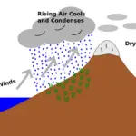
- Precipitation: Mountainous areas often receive more rainfall due to orographic uplift.
- Atmospheric Pressure: Decreases with increasing altitude.
2. Latitude as a Climate Factor
Latitude is the angular distance of a place north or south of the Equator. It is the most significant factor determining the amount of solar radiation a region receives.
The influence of latitude on climate includes:
- Temperature: Areas near the Equator (low latitudes) receive direct sunlight, leading to high temperatures. Areas near the poles (high latitudes) receive slanted sunlight, resulting in colder temperatures.
- Length of Day and Night: Varies significantly with latitude, affecting solar heating.
- Climatic Zones: Leads to the formation of distinct climatic zones (e.g., Tropical, Temperate, Polar).
3. Slope and Aspect Effects on Climate
Slope refers to the steepness of the land, while aspect is the direction a slope faces. These factors create microclimates within small areas.
The effects of slope and aspect on climate are:
- Temperature: Slopes facing the sun (e.g., south-facing in the Northern Hemisphere) receive more direct sunlight and are warmer than slopes facing away from the sun.
- Vegetation: Warmer, sunnier slopes may support different plant life compared to cooler, shaded slopes.
- Moisture: Windward slopes often receive more moisture, while leeward slopes are drier.
4. Continentality and Distance from the Sea
Continentality describes the degree to which the climate of a place is affected by its proximity to a large landmass (continent) rather than the sea.
The effects of continentality and distance from the sea are:
- Temperature Range: Inland areas (high continentality) experience a greater annual and daily temperature range (hot summers, cold winters) because land heats up and cools down faster than water. Coastal areas have a more moderate temperature range.
- Precipitation: Coastal areas often receive more rainfall due to moisture from the sea. Inland areas can be drier.
- Humidity: Coastal areas tend to have higher humidity compared to inland areas.
5. Local Examples of Climate Controls
These factors combine to create the specific climates we observe locally.
Examples include:
- The cooler temperatures experienced in Jos Plateau (due to high altitude) compared to Lagos (coastal and low altitude).
- The heavy rainfall in coastal cities like Port Harcourt compared to drier inland areas like Maiduguri (due to distance from the sea).
- The distinct microclimates found on different sides of a hill in a rural area (due to slope and aspect).
Teaching Methods/Instructional Techniques
Discussion, Lecture, Demonstration, Question and Answer, Visual Aids
Instructional Procedures
Step 1: Introduction
Time: 5 minutes
Teaching Skill: Set Induction
Teacher’s Activity: The teacher greets the pupils and asks them to recall the difference between weather and climate. The teacher then asks what they think makes some places hotter or colder, or receive more rain than others, leading to the topic of factors affecting climate.
Pupils’ Activity: Pupils respond to questions and share their ideas about what causes climatic differences.
Learning Point: Pupils recall previous knowledge and are introduced to the lesson’s topic.
Step 2: Explanation of Altitude as a Climate Factor
Time: 8 minutes
Teaching Skill: Explanation/Illustration
Teacher’s Activity: The teacher explains altitude and how it affects temperature and precipitation. The teacher uses diagrams or a map to show high and low altitude areas and gives examples like the Jos Plateau.
Pupils’ Activity: Pupils listen, observe the diagrams, ask questions, and contribute local examples.
Learning Point: Pupils understand how altitude influences climate.
Step 3: Explanation of Latitude as a Climate Factor
Time: 7 minutes
Teaching Skill: Explanation/Demonstration
Teacher’s Activity: The teacher uses a world map or globe to demonstrate how the sun’s rays hit different latitudes, explaining the concept of direct and slanted rays. The teacher relates this to temperature variations and climatic zones.
Pupils’ Activity: Pupils observe the globe, identify the Equator and poles, and discuss how sunlight angle affects temperature.
Learning Point: Pupils understand the relationship between latitude and temperature/climatic zones.
Step 4: Explanation of Slope and Aspect Effects on Climate
Time: 7 minutes
Teaching Skill: Illustration/Discussion
Teacher’s Activity: The teacher explains slope and aspect using sketches or drawing on the board. The teacher discusses how sun-facing and shaded slopes can have different temperatures and vegetation, creating microclimates.
Pupils’ Activity: Pupils examine the sketches, identify different slopes, and discuss how these affect local conditions.
Learning Point: Pupils grasp how topography creates microclimates.
Step 5: Explanation of Continentality and Distance from the Sea
Time: 7 minutes
Teaching Skill: Explanation/Comparison
Teacher’s Activity: The teacher explains continentality and how distance from the sea affects temperature range and rainfall. The teacher compares the climate of coastal cities (e.g., Lagos) with inland cities (e.g., Kano) to illustrate the point.
Pupils’ Activity: Pupils listen, compare the climate characteristics of coastal and inland areas, and ask clarifying questions.
Learning Point: Pupils understand the moderating effect of the sea and the extreme nature of continental climates.
Step 6: Local Examples of Climate Controls
Time: 4 minutes
Teaching Skill: Application/Synthesis
Teacher’s Activity: The teacher guides a discussion on how these factors combine to explain climate patterns in Nigeria, using specific Nigerian examples (e.g., Jos, Port Harcourt, Maiduguri). The teacher encourages pupils to relate the factors to observed weather patterns in their own area.
Pupils’ Activity: Pupils contribute local examples and discuss how the different factors influence the climate of various Nigerian regions.
Learning Point: Pupils apply their understanding to real-world local climate scenarios.
Step 7: Evaluation/Review
Time: 5 minutes
Teaching Skill: Questioning/Assessment
Teacher’s Activity: The teacher evaluates the learning by asking the following questions:
- Define altitude and explain how it affects temperature.
- State two ways latitude influences climate.
- Mention one effect of a slope’s aspect on its temperature.
- Explain the term “continentality” and its impact on temperature range.
- Give one Nigerian example where distance from the sea affects rainfall.
Pupils’ Activity: Pupils answer orally and in writing.
Learning Point: Pupils demonstrate understanding of the lesson.
Step 8: Conclusion
Time: 2 minutes
Teaching Skill: Consolidation
Teacher’s Activity: The teacher summarizes the main points of the lesson, reiterating the key factors affecting climate and their importance. The teacher assigns homework, asking pupils to observe and record daily temperature and rainfall for a week in their locality and identify potential influencing factors.
Pupils’ Activity: Pupils listen to the summary, ask final questions, and note down the homework.
Learning Point: Pupils review the lesson and prepare for further observation.
Lesson Keywords
- Altitude – The height of a place above sea level.
- Latitude – The angular distance of a place north or south of the Equator.
- Slope – The steepness of the land.
- Aspect – The direction a slope faces, especially in relation to the sun.
- Continentality – The effect of a large landmass on climate, leading to extreme temperatures.
- Microclimate – The climate of a very small or restricted area, especially when differing from the climate of the surrounding area.
Differentiation
The teacher will provide additional visual aids and simplified explanations for struggling learners. Advanced learners will be encouraged to research and present on specific microclimates or extreme climate examples influenced by these factors globally.
Note for teachers using this lesson plan
Teachers should encourage pupils to use local examples to make the concepts more relatable. Practical demonstrations using simple instruments or real-time weather data can enhance understanding. Emphasize the interconnectedness of these factors in shaping a region’s overall climate.



Community Join the conversation Open discussion +