

Class: Junior Secondary School 1 (JSS1, JSS 1)
Term: 3rd Term
Week: 10
Age: 12 years
Duration: 45 minutes
Subject: Basic Science
Curriculum Theme: Basic Science And Technology
Previous Lesson: .
Topic: Satellites
Subject Matter: Meaning Of Satellites, Uses Of Satellites In Communication, Photography, Mapping, Application Of Geographic Information System (GIS).
Specific Objectives
By the end of the lesson, pupils should be able to:
Cognitive Domain:
- Define what a satellite is.
- List at least three uses of satellites.
- Explain the meaning of Geographic Information System (GIS).
- Identify applications of GIS.
Affective Domain:
- Appreciate the importance of satellites in modern life.
- Show interest in how satellite technology works.
- Recognize the impact of satellites on communication and mapping.
Psychomotor Domain:
- Draw a simple sketch of a satellite.
- Identify images or data obtained from satellites (e.g., weather maps).
Social Domain:
- Discuss with peers the various ways satellites benefit society.
- Collaborate in identifying everyday uses of satellite technology.
Reference Materials
The following resources were used in planning this lesson:
- 9 Years Basic Education Curriculum for Basic Science.
- State Unified Scheme of Work for Junior Secondary Schools.
- Basic Science for Junior Secondary Schools 1 by P.A. Okebukola et al.
- NASA: What is a Satellite?
Instructional Materials
The teacher will teach this lesson with the aid of:
- Charts showing different types of satellites and their orbits.
- Video clips demonstrating satellite launch and functions.
- Pictures of satellite images used for weather forecasting, mapping, and communication.
- A world map or globe.
Rationale for the Lesson
This lesson helps pupils understand how objects in space, called satellites, are important in our daily lives for things like talking on the phone, watching TV, and checking the weather. It enables them to see how technology developed in science affects society and helps solve real-world problems.
Prerequisite/Previous Knowledge
Pupils are assumed to have a basic understanding of space, planets, and simple communication methods.
Lesson Content/Board Summary
Satellites
1. Meaning of Satellites
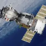
A satellite is an object that orbits, or revolves around, another object. In space, satellites can be natural, like the Moon orbiting the Earth, or artificial (man-made), like the ones we send into space for various purposes.
2. Uses of Satellites
Artificial satellites have many important uses. The following are some common uses of satellites:
- Communication: Satellites relay telephone calls, television signals, and internet data across long distances, making global communication possible.
- Photography/Remote Sensing: Satellites take pictures of the Earth’s surface and atmosphere. These images are used for weather forecasting, studying climate change, and monitoring natural disasters.
- Mapping/Navigation: Satellites are used to create detailed maps of the Earth and provide navigation services, such as the Global Positioning System (GPS), which helps people find their way.
- Scientific Research: Some satellites are used to study space, planets, and stars, helping scientists understand the universe better.
- Military/Defense: Satellites are also used for surveillance and intelligence gathering for national security.
3. Application of Geographic Information System (GIS)
Geographic Information System (GIS) is a computer system designed to capture, store, manipulate, analyze, manage, and present all types of geographical data. GIS uses data collected by satellites.
GIS applications include:
- Urban Planning: Helps in planning city development, managing infrastructure, and identifying suitable locations for new projects.
- Environmental Management: Used to monitor deforestation, pollution, and the impact of human activities on the environment.
- Disaster Management: Aids in mapping areas affected by floods, earthquakes, or other disasters, and planning relief efforts.
- Agriculture: Helps farmers monitor crop health, soil conditions, and optimize irrigation.
- Resource Management: Used for managing natural resources like forests, water bodies, and mineral deposits.
Teaching Methods/Instructional Techniques
Discussion, Lecture, Demonstration, Question and Answer, Visual Aids
Instructional Procedures
Step 1: Introduction
Time: 5 minutes
Teaching Skill: Set Induction
Teacher’s Activity: The teacher greets the pupils and asks them to name any objects they know that orbit around another object (e.g., Moon around Earth). The teacher then introduces the topic “Satellites” and explains that today’s lesson will cover what satellites are and their uses.
Pupils’ Activity: Pupils respond to the questions and listen attentively.
Learning Point: Pupils are introduced to the concept of orbiting objects and the lesson topic.
Step 2: Meaning of Satellites
Time: 8 minutes
Teaching Skill: Explanation/Definition
Teacher’s Activity: The teacher explains the meaning of a satellite, distinguishing between natural and artificial satellites. The teacher uses charts to show examples of different types of artificial satellites.
Pupils’ Activity: Pupils listen, ask questions, and define a satellite in their own words.
Learning Point: Pupils understand the definition of a satellite and differentiate between natural and artificial types.
Step 3: Uses of Satellites (Communication)
Time: 7 minutes
Teaching Skill: Illustration/Discussion
Teacher’s Activity: The teacher discusses how satellites are used for communication, giving examples like TV broadcasts, phone calls, and internet services. The teacher may show a short video clip on how communication satellites work.
Pupils’ Activity: Pupils identify communication devices that use satellite technology and discuss their experiences.
Learning Point: Pupils understand the role of satellites in global communication.
Step 4: Uses of Satellites (Photography & Mapping)
Time: 7 minutes
Teaching Skill: Demonstration/Explanation
Teacher’s Activity: The teacher explains how satellites are used for photography and mapping. The teacher shows pictures of satellite images used for weather forecasting, Google Maps, or environmental monitoring.
Pupils’ Activity: Pupils observe the images and discuss how they have personally used or seen such applications (e.g., checking weather, using maps on phones).
Learning Point: Pupils grasp how satellites contribute to photography, weather forecasting, and mapping.
Step 5: Application of Geographic Information System (GIS)
Time: 8 minutes
Teaching Skill: Explanation/Examples
Teacher’s Activity: The teacher defines GIS and explains how it uses satellite data for various applications like urban planning, environmental monitoring, and disaster management. The teacher provides simple, relatable examples for each application.
Pupils’ Activity: Pupils listen and identify real-life scenarios where GIS might be used.
Learning Point: Pupils understand the concept of GIS and its practical applications.
Step 6: Class Activity/Discussion
Time: 5 minutes
Teaching Skill: Group Work/Collaboration
Teacher’s Activity: The teacher divides pupils into small groups and asks them to discuss everyday items or services they use that rely on satellites.
Pupils’ Activity: Pupils discuss in groups and share their findings with the class.
Learning Point: Pupils reinforce their understanding through peer discussion and practical examples.
Step 7: Evaluation/Review
Time: 5 minutes
Teaching Skill: Questioning/Assessment
Teacher’s Activity: The teacher evaluates the learning by asking the following questions:
- Define what a satellite is.
- List three uses of satellites.
- What does GIS stand for?
- Mention two applications of GIS.
Pupils’ Activity: Pupils answer orally and in writing.
Learning Point: Pupils demonstrate understanding of the lesson.
Step 8: Conclusion
Time: 2 minutes
Teaching Skill: Summarization
Teacher’s Activity: The teacher summarizes the key points of the lesson, emphasizing the importance of satellites and GIS in modern society. The teacher assigns homework: “Draw and label a simple artificial satellite and write one sentence about its function.”
Pupils’ Activity: Pupils listen to the summary and copy the homework.
Learning Point: Pupils consolidate their learning and are given an activity to reinforce the lesson.
Home Task: Record two correct examples of Satellites from the lesson or home environment and explain each in your own words.
Lesson Keywords
- Satellite – An object, either natural or artificial, that orbits a larger object in space.
- GIS (Geographic Information System) – A computer system for capturing, storing, analyzing, and managing geographical data.
- Communication – The process of sending and receiving information, often over long distances using satellites.
- Mapping – The process of creating maps, often using data from satellites.
- Orbit – The curved path of a celestial object or spacecraft around a star, planet, or moon.
Differentiation
For pupils who grasp concepts quickly, the teacher can ask them to research different types of orbits or specific satellite missions. For pupils needing more support, the teacher will provide simplified definitions, use more visual aids, and pair them with more capable peers during group activities.
Note for teachers using this lesson plan
Ensure that the video clips or images used are age-appropriate and directly illustrate the concepts being taught. Encourage pupils to relate the uses of satellites to their daily experiences to make the lesson more engaging and relevant.
Community Join the conversation Open discussion +